Winter Storm Gianna is underway in the South, bringing heavy snow to the Carolinas and parts of Georgia before it pivots offshore and deepens into a powerful bomb cyclone that could bring blizzard conditions to the coasts of North Carolina and Virginia.
We’ll be tracking the latest from this winter storm all day, so follow below for the latest updates and refresh the page frequently to reveal new entries.
(MORE: Winter Storm Gianna’s Latest Forecast | Maps Tracker Page)
(08:12 a.m. EST) When Will Artemis II Launch?
From managing editor Sean Breslin:
With temperatures plunging in Florida this weekend, that has put the launch of NASA’s Artemis II rocket in question.
“NASA is targeting Monday, Feb. 2, as the tanking day for the upcoming Artemis II wet dress rehearsal at the agency’s Kennedy Space Center in Florida, as a result of weather,” according to a release. “With this change, the first potential opportunity to launch is no earlier than Sunday, Feb. 8.”
The timeline was changed due to the arctic cold outbreak that could affect hardware capabilities as engineers make final preparations for the launch. Temperatures at Cape Canaveral, Florida, are expected to dip to freezing or colder in each of the next two nights.
When Artemis II launches, it will be the first crewed mission to the moon in more than a half-century.
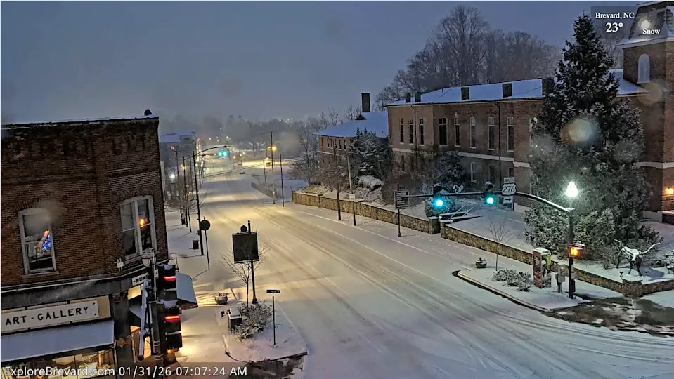
(07:46 a.m. EST) A Live Camera To Keep An Eye On

(Courtesy of ExploreBrevard.com)
From producer Carmen Molina:
Do you want to see Winter Storm Gianna moving through the Carolinas? You can watch it live through the lens of a high-definition live streaming camera in Brevard, North Carolina. The camera can be found at ExploreBrevard.com.
(07:31 a.m. EST) See The Snow In North Georgia
From writer Toby Adeyemi:
Blairsville, Georgia, has seen noticeable snowfall since the early morning hours and it’s quite the sight. It’s also starting to stick to the roads, so if you are leaving your home, please be careful. Snow is expected to continue throughout the day and push southward in the state, including into metro Atlanta.
(07:11 a.m. EST) Snowfall Spreading To North Georgia
From digital meteorologist Rob Shackelford:
Snowfall has begun to move into north Georgia and will continue to spread south into metro Atlanta through the day.
Winter storm warnings are expected to remain until early Sunday for the majority of Georgia. The heaviest snowfall is expected across northeastern Georgia, where widespread totals of 3-6 inches are expected. Isolated totals could even exceed 6 inches.
Gusty winds could make travel very dangerous, so travel is not recommended.
(06:52 a.m. EST) ‘Travel Is Not Advised’ In Pigeon Forge

Facebook/Pigeon Forge Police Department
There’s nothing that screams “Pigeon Forge” more than a Dollywood sign. But this morning, roads in the East Tennessee town were covered in snow, and that’s bound to cause problems today.
“Travel is not advised at this time so crews can safely treat area roads,” said the Pigeon Forge Police Department in a Facebook post. “Many roads are slick and unsafe.”
The department urged everyone to stay home today if possible. Nearby Gatlinburg has already reported 2.5 inches of snow.
(06:31 a.m. EST) Here’s Who Has The Most Snow So Far
According to snow observations from the National Weather Service, several locations in eastern Tennessee and western North Carolina saw more than 5 inches of snow yesterday into this morning.
– Near Faust, North Carolina: 6.8 inches
– Bristol, Tennessee: 5.3 inches
– Near Surgoinsville, Tennessee: 5.3 inches
– Liberty, Tennessee: 5 inches
(06:06 a.m. EST) Cold Alerts Map Lit Up Like A Christmas Tree Again …

… and this doesn’t even include the winter storm advisories and warnings. Luckily, meteorologist Caitlin Kaiser compiled everything in a way that makes sense — head over to our maps tracker page to see everything related to this winter storm and cold outbreak.
(05:52 a.m. EST) Gianna Brings A Mess To A Region Already In Bad Shape

AP Photo/George Walker IV
This weekend’s winter storm will track across some of the same areas hit hard by last weekend’s Winter Storm Fern. But luckily, in most of the states hit hardest by Fern — Tennessee, Mississippi and Louisiana specifically — additional impacts aren’t expected from Gianna. That trio of states still has more than 150,000 homes and businesses without power this morning, according to PowerOutage.us.
It has been a very cold, frustrating week for those customers, and a long week for crews who have worked around the clock to restore power and clear tree damage caused by last weekend’s ice storm.
(05:30 a.m. EST) Cancellations Mounting At Southern Airports
As we start the morning’s coverage, there are already hundreds of flight cancellations at two major hubs in the South. According to the flight-tracking website FlightAware, Atlanta’s Hartsfield-Jackson International and Charlotte Douglas International are No. 1 and No. 2 in the nation with more than 500 flights canceled into and out of each airport today.
Raleigh-Durham International Airport is a distant third with 120 flights canceled so far. Earlier this week, Hartsfield led the country in cancellations due in part to the ice brought by Winter Storm Fern.